


History Society Report
Disputes over boundaries and commons in the South Pennines
Speaker:Dr. Nigel Smith
Thursday, 5 April 2018
The Alan Petford Memorial Lecture 2018
To the eye of the average walker, the moorland hills around Hebden Bridge might seem miles away from dispute and confrontation, but research carried out by Dr Nigel Smith, tells how disagreements over the location of township boundaries reached a peak of litigation in the 16th and early 17th centuries. As he told a meeting of the Hebden Bridge Local History Society, some of these disputes rumbled on even until the mid 19th century.
Then as now a boundary dispute was about access to resources, and this was the case on these moorland commons.
The land known as common was owned by the Lord of the Manor, with individual landowners given rights of access and use. These included the rights to graze animals; to get peat, clay, sand and stone; and to gather berries, rushes, heather and bracken which were so useful to upland farmers. Often a dispute arose because of over-grazing. Each owner was allowed to put a certain number of animals on the moorland commons, and if cattle owned by men from neighbouring townships were allowed to trespass, the value of the grazing was threatened.
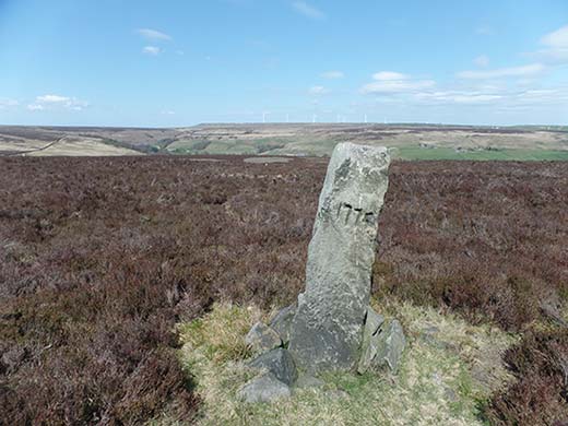
On the often featureless moorlands boundaries are hard to discern; they could be marked by some kind of natural feature such as a ridge, or by manmade lines of stones. But boundary stones can fall over, or be dug up and moved, while natural ditches become silted up and watercourses change direction. Sometimes there was an attempt to settle a dispute by calling on the memory of residents, but this was far from perfect. In a dispute between Ovenden and Thornton townships the men of each place were set to walk the boundary between two named features. On each occasion, the lines diverged more and more, as Thornton men marched a line further to the south, claiming more land that Ovenden men thought was theirs.
Sometimes these disagreements took years to settle. A boundary between Wadsworth and Midgley contested at the end of 16th century was indicated with boundary markers in the 1590s but still marked as ‘disputed ground’ on the Myer’s map of 1835. Nigel’s research has focused especially on disputes in Langfield township on the south side of the Calder, including the high ground of Mankinholes Moor. A dispute over land here in 1605 involved the Duchy of Lancaster whose Court examined witnesses and finally appointed its surveyor William Yewart, to make a map to clarify the situation. It was fascinating to see the range of resources which Nigel has explored, including proceedings recorded in the courts, and the map itself. A significant part of his research is searching for the evidence that remains in the landscape and is hinted at in place names.
The witnesses to the Duchy Court spoke of a ‘moondike’ or ‘mondike’ which in earlier documents is described as the ‘mandike’ – a ditch used to mark a boundary. The name ‘Dick’s Lane’ probably also relates to such a boundary ditch, and its Anglo Saxon origins suggest great antiquity. Nigel has located traces of the mandike, and also some stones which were used to mark this ancient boundary in about 1699. You can encounter boundary stones on the moors, often fallen over, sometimes moved, and bearing the signs of the ancient quarrel when markings to indicate ownership have been defaced.
We tend to think of Ordnance Survey maps as definitive, but surveyors relied on local knowledge of ‘meresmen’ to identify correct boundaries, producing a sketch map that would then be open for comment. A boundary between Langfield and Rochdale is marked as ‘undefined’ on the first edition map and was re-investigated in 1890. The Boundary Remark Book kept by the surveyors recorded changes showing the addition of a line of stones where the boundary was thought to be. But by the time of the second edition map in 1908, these were marked simply as stones, rather than boundary stones, and a portion of Lancashire was absorbed into Yorkshire.
Nigel’s research is written up in more detail in the book which he edited, ‘History in the South Pennines: the legacy of Alan Petford’ which stands as a testament to the continuing and wide ranging influence of the man who encouraged so much a study of local history.
There will be an extra meeting of the Hebden Bridge Local History Society at the Methodist Church on Wednesday 18th April at 7.30, when Nick Wilding will repeat his talk about Seven centuries of recorded floods in the Calder Valley, which many people were unable to get to because of the snow.
With thanks to Sheila Graham for this report
Details of all the Society’s activities can be found on the website and you can also follow them on their Facebook page.
See also