

Slow the Flow project maps local activity to reduce flooding risk
Friday, 18 October 2019
Slow The Flow Calderdale have worked in the Calder Valley for the last three and a half years to encourage and empower the community and organisations to take action on their own property and land to reduce flood risk on a local level.
Small‐scale interventions
Many small‐scale interventions, taken together, can result in a significant amount of water being temporarily stored, or attenuated, during storm events.
These interventions help to reduce peak flows which, together with wider catchment management and traditional flood defenses, contribute to reducing the scale and damaging effects of flood events.
'Opportunity Mapping' project
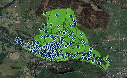
Slow The Flow’s latest project ‘Opportunity Mapping’ is based in Mytholmroyd, West Yorkshire. It provides geographic detail and specific advice for many parts of Mytholmroyd, providing practical suggestions for rural Natural Flood Management (NFM) and urban Sustainable Drainage (SuDS) in Mytholmroyd.
This Opportunity Mapping in Mytholmroyd contributes to the physical Natural Flood Management work undertaken by Slow The Flow Calderdale with the Calderdale Natural Flood Management Operations Group partners to address actions in the Calderdale Flood Action Plan. ‘Mapping Natural Flood Management opportunities’ is an action in that plan.
This pilot project has been grant funded by Hebden Royd Town Council and the Community Foundation for Calderdale.
Local interventions
The mapping identifies realistic locations on a field / street level of detail in Mytholmroyd, where residents, businesses and organisations can contribute to flood alleviation through natural and sustainable interventions, and give indications as to what interventions might be appropriate in those locations.
Interventions include Rain Gardens, Green roofs, Water butts, Swales, Ponds, Detention basins and Tree planting.
Urban locations include public highways, schools, public parks and other Local Authority / publicly owned sites. They could also include commercial properties, car parks, residential gardens & driveways including opportunities for neighbours to work together. Opportunity mapping should also be used in the development of sites identified in local plan
Rural locations might include Local Authority owned sites, woodlands, farm land and fields, and rural private property.
The exercise is informed by OS and Google mapping, teamed with local knowledge, and on-site ground-truthing exercises. It includes locations where retrofit is possible; and intends to inform and inspire any future renovation works.
Bill Blackledge, Managing Director of 2B Landscape Consultancy, who contributed to the opportunities mapping, said, “Early calculations, made against major flood events in the valley, suggest that these Natural Flood Management/urban Sustainable Drainage interventions could have had a notable impact upon 2000, 2012 and 2015 flooding levels. The fact that the study area was limited to the north side of the railway suggests that greater impacts could be achieved if both sides of the valley were assessed. More work is needed to check and to relate these figures to wider Natural Flood Management/urban Sustainable Drainage implementation, but this early work is very promising.”
Bede Mullen, Chair of Slow The Flow Calderdale said, “This project is massively important in encouraging landowners and householders to take on small scale schemes to reduce flood risk in their own areas. While this particular scheme is centred on Mytholmroyd in West Yorkshire, lessons can be learnt here on how any landowner can make a significant contribution to flood risk, wherever you live.
"We hope that the work this project promotes will be adopted beyond the Calder Valley because it is clear how beneficial these sustainable drainage and natural flood management schemes can be in reducing flood risk. "
Scott Patient Calderdale council Cabinet member for Climate Change and Environment said, “Slow the Flow have been instrumental locally in encouraging the community to help make the valley more flood resilient. Their excellent work in Hardcastle Crags has seen hundreds of volunteers stuffing gullies and building leaky dams.
This new project takes it one step further, to Mytholmroyd, still very much picking up the pieces from Boxing Day 2015. This mapping identifies ways we can pull together as a community and use our homes, gardens and land to slow the flow.
"I urge people to explore the map and see where they can help"
By making this mapping publicly available, Slow The Flow Calderdale hopes it will encourage and enable the suggested rural Natural Flood Management and urban Sustainable Drainage actions to be reviewed, considered and undertaken by the householder or landowner and will serve as an example for other communities to take on similar schemes.
Slow The Flow is looking for funding to extend the opportunities mapping throughout the Calder valley.