

Wednesday, 2 January 2013
Postcard from Palestine 10 - Leaving Bethlehem
Hebden Bridge's Ron Taylor is a regular visitor to Palestine, part of an international movement of supporters.
(This postcard is not actually from Palestine as I arrived back in Hebden Bridge a couple of weeks before Christmas.)
Just a few facts about Bethlehem.
Bethlehem is more than 2,500 feet above sea-level
The ‘little town’ of our Christmas carols and cards is now rather a sprawling urban area of 30,000 people (60,000 if the seamlessly attached towns of Beit Jala and Beit Sahour are counted in), half of whom live in the three refugee camps - Azzar, Aida and Dheisheh.
Bethlehem is also the administrative centre for the Bethlehem Governorate, the equivalent of a county council here in the UK, which has a population of about 180,000. It stretches from the Green Line (Israel’s only internationally recognised border) in the west to the Dead Sea in the east, from the border with Jerusalem and the Apartheid Wall in the north and south to the area around Hebron.
As I left the West Bank, exiting through the ghastly checkpoint towards Jerusalem, the people of Bethlehem were gearing themselves up for Christmas. The big artificial tree was being erected near the Nativity Church and the hotels were being readied for an influx of tourists. Shopkeepers were stacking their shelves with the usual Xmas tat (much of it made in China) and a blow-up Santa had appeared on Manger Street.
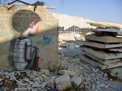
The Wall near Aida refugee camp, Bethlehem.
Below ground is a road tunnel for Jewish settlers.
Of course, it is Bethlehem’s history and its association with Christianity which brings the visitors in. And it certainly has a long and fascinating past. But the people of Bethlehem ask themselves whether they have a future. The truth is that modern Bethlehem is being strangled by Israeli policies to the extent that only 13 per cent of the Governorate’s 660 square kilometres is available for Palestinian development.
Two thirds of the land is classed as Area C which, under the now discredited Olso Peace Accords, remains under full Israeli military control. Palestinians who wish to build anything, a sheep pen or a water cistern, must apply to the Israeli military for a permit to do so. Permits are rarely granted. A further 20 per cent is defined as ‘Nature Reserves’ and again is effectively controlled by Israel. ( Incidentally I have hiked in these areas many times but have never seen any signs of nature being conserved there).
Large tracts of Area C have been confiscated by the Israelis to build Jewish-only settlements and settlement outposts, all of which are illegal under international law. According to the UN in 2009 in the Bethlehem area there were 19 settlements and 16 outposts with a total population of 86,000. The figures will now be higher as since then new outposts have been set up and very recently the building a new settlement was announced by the Israeli government. More are planned.
As a result most Palestinian villages have lost land vital to maintaining their livelihoods. Some are completely surrounded by settlements and struggle to survive. The short video below illustrates the problem. It was made in the village of Beit Iskaria just a few miles south of Bethlehem. I have been there a number of times to help with the olive harvest and to plant olive trees many of which have been destroyed by settlers.
Associated with the building and expansion of settlements is the infrastructure needed to connect them to Israel. A series of by-pass roads, tunnels and bridges have been built around Bethlehem so that settlers can access Jerusalem and other Israeli towns quickly without having to pass through Palestinian communities. A considerable amount of mainly agricultural land was taken to construct them.
Then, just a mile or so north of Bethlehem’s centre is The Wall. Known by the Israelis as the Separation Barrier, Palestinians have other names for it - The Apartheid Wall or The Annexation Wall are the most common. This ugly concrete monstrosity does separate - it prevents over 90 per cent of Palestinians from reaching Jerusalem - and it also annexes. Israel confiscated 10 square kms of Bethlehem land to build it having also stolen nearby land to build settlements which have now been incorporated into Jerusalem.
Palestinians want and need to develop their communities and their land to survive. Unemployment in the Bethlehem area now stands at 20 per cent of the population - the highest in the West Bank. There are few opportunities for often well-qualified young people. Many leave to work overseas without ever having had the chance to really contribute to their own society. Others dream of joining them.The noose around Bethlehem is tightening and Israel seems bent on strangulation.
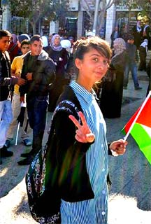
A Palestinian girl, Manger Square, Bethlehem, November 29th 2012- the day the UN voted to recognise the State of Palestine.
Thanks to Hebweb for posting the Postcards.
Ron Taylor
See also
HebWeb Forum - Postcards from Palestine
Postcard from Palestine 9 - Destroying Palestine Bit by Bit
Postcard from Palestine 8 - Trees destroyed in revenge
Postcard from Palestine 7 - Normal life in Palestine
Postcard from Palestine 6 -Beer festival and closed military zones (2 November 2012)
Postcard from Palestine 5 - April 2012
Postcard from Palestine 4 - attacked by settlers
Postcard from Palestine 3 - detained by the Israeli army (16 March 2012)
Postcard from Palestine 2 (19 Feb 2012)
HebWeb Forum: Postcard from Palestine
Postcard from Palestine 1 (8 Feb 2012)
HebWeb News - Hebden Bridge Old Gits support Palestinian farmers